Long, long ago……
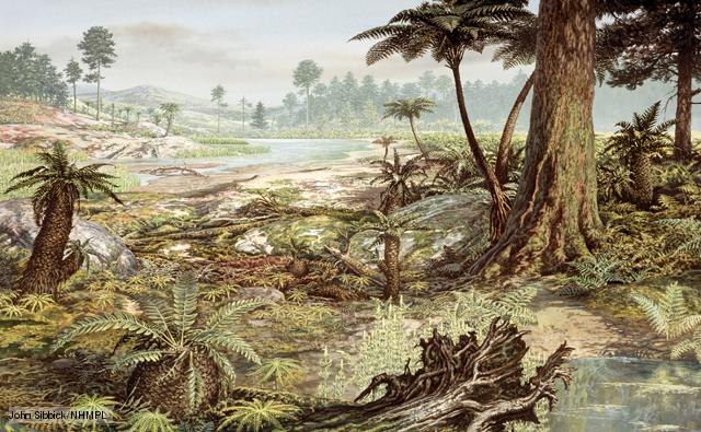
About 300 million years ago, the land we know as England was much nearer to the equator and had a tropical climate. It was covered by a shallow tropical sea and the shells and bones of dead creatures sank to the sea bed, when compressed these formed chalk or limestone.
Over the following 100 million years or so the sea level fluctuated. When sea level was low, a huge swampy area developed. The plants were huge and vegetation was lush. The action of heat and pressure caused the decayed tropical vegetation to be firstly converted into peat and then into coal, and the intervening sediments into rock strata. It is these Carboniferous sediments that form the solid geology of the area—the Lancashire Coalfield.
The land under Wigan
If we travel down through these rocks for nearly 3,000 feet [ 750m] we find alternating bands of fireclay, coal, mudstone, shale and sandstone.
The coal seams themselves vary in thickness from a few inches to about nine feet [2.7m], and are separated from each other by up to several hundred feet of rock.
The coal varies in quality and it is not economical to work the very thin seams. However, seams of good quality coal as thin as fourteen inches [35 cm.] have been worked and there are some miners who actually preferred to work under these difficult conditions.
In the Wigan area, these coal measures were downfolded into a basin, with the oldest rocks outcropping along the Billinge Ridge to the west and at Haigh to the east.
This bending of the rocks means that the horizontal beds of rock strata have been severely faulted and fragmented, with the result that coal seams crop out very frequently at the surface. It is at these points that they are easily reached and worked.
From the outcrop, many seams dip steeply underground. The sloping, narrow coal seams mean that getting coal in this area was not easy.

1066 and all that——-
After the Battle of Hastings-1066- William set about rewarding his friends and making sure he could control the far flung parts of his kingdom, even Wigan.
In Saxon times Ashton was an outlying estate of the Manor of Newton and was absorbed into William the Conqueror’s domain.
The Gerards became Lords of the Manor from about 1340.and they lived at Old Bryn Hall at Landgate, in a moated hall. The site of this was a field to the south and east of Landgate Lane, near the railway line.
The Industrial Revolution.
The demand for coal increased to fuel the Industries needing steam power and so the coal getting became more organised, with Coal owners buying the mining rights from the Land Owners.
The site of the Three Sisters was bought by a company that became known as The Garswood Hall Coal and Iron Company, founded in 1883. They are shown on maps of 1861 and by 1887 a newspaper report shows they were sinking No. 5 pit so the first shaft may have been sunk in the early 1800s.
At the end of the fourteenth century they moved to New Bryn Hall which stands just outside the boundary of the Three Sisters, on the NE perimeter.
In the eighteenth century they moved from here to Garswood and later Garswood Park, which is where Ashton Golf Club now stands.
There has been ‘getting of coal’ in the area from the 16th C and maybe earlier as where ever coal outcropped it would be dug out and used. The coal seams that were under Wigan tilted upwards towards Ashton so that the coal seams around Ashton were very near the surface and often outcropped.
Coal was dug out where it outcropped and used by locals for heating.
Garswood Hall Collieries
From a newspaper report of 1887:-
April 1887 Interesting Ceremony at Bryn.
New shafts were opened by the Garswood Company on the dip side of the Wigan fault line.
The first sod was cut by Mrs R Edmonson, wife of the then Chairman.
Mr James McGeevor, the General Manager, presented her with a beautiful silver spade, engraved for the occasion and boasting an elaborately carved ebony handle. Following the speeches the lady ‘truely and efficiently cut the first sod amid applause and named it number 5 pit.
The Garswood Hall Collieries were a huge undertaking and over the years employed many thousands of men, women and children.
By 1911 there were 2440 men employed in getting coal but this number slowly declined.
After the Royal Commission of 1842, Women and children under 14 were not allowed to work underground but did continue to work at the pithead.
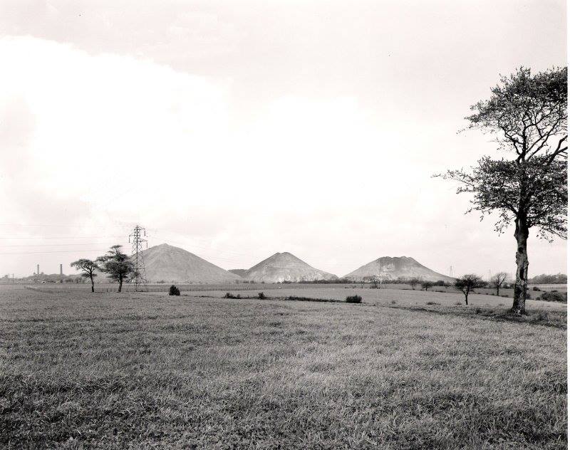
The famous Pit Brow Lasses, who have a unique place in mining history, worked above ground on the screens, sorting, cleaning and grading coal. The dirt from these screens was carried to the ever growing tips and dumped. This was how the Three Sisters were born and how they grew.
They were well over 150 feet high when the pits closed in autumn 1958.
The remaining 500 miners moved to work at other pits in the area.


Dirt and Dereliction.
After the closure of the pits the land was an unloved area of dirt and industrial dereliction. The Three Sisters were a well know local land mark known as the Wigan Alps, visible for miles around.They were surrounded by pools of dirty water, piles of clay and broken down buildings.
In the early 1960s the 80 acres of derelict land was bought by Lancashire County Council [LCC] and towards the end of that decade a grant from the Department of the Environment enabled LCC to start a program of reclamation.
3.5 million tons of earth were moved and reshaped.
10 miles of surface water ditches, drains and sewers were laid.
21 million gallons of water along with an equivalent volume of silt, was pumped out.

logs

logs
fots_logo
fots_logo_mob
pontoon2
At government re-organisation in 1974 the project was taken over by Greater Manchester Council and was finally handed over to Wigan Metropolitan Borough for completion and management.
The Three Sisters Recreation Area was opened to the public in November 1978
The culmination of a plan to make formerly barren, industrial land useful again.
The site had a Visitors’ Centre, a motor racing circuit and a lake.
During the following years trees were planted, paths laid around the site and meadows formed.
With the cut back of public expenditure during the 1980s, further development stopped but the trees and meadows flourished and provided a rich habitat for much wildlife.
The site now has Local Nature Reserve status and is a well used and much loved site.